An alternative vision in the paradigm of tomorrow's cities and a solution against the consequences of climate change in the country.
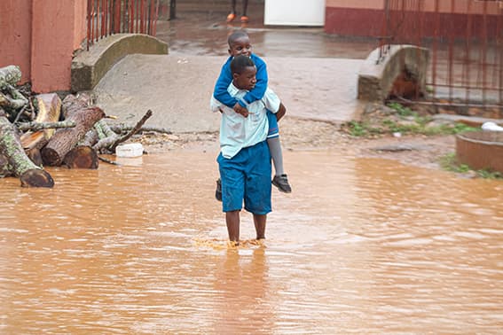
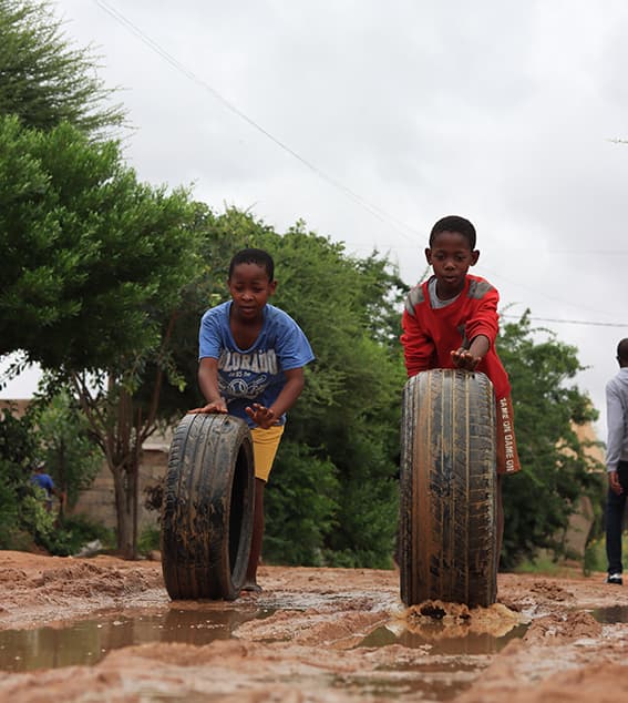
Floods have been recorded in Rwanda since the 1960s, but in recent years their frequency has increased dramatically. In the first 15 years of the 21st century (2000-2015), 183 people were killed by 12 major floods, and between 2018 and 2020 more than 250 people died due to this phenomenon (Niyokwiringirwa, 2021). On 7 May 2020, 140 mm of rain fell in Kigali in 24 hours, killing 65 people, according to the reports of MINEMA (Ministry of Emergency Preparedness). In December 2019, MINEMA and the Rwanda Red Cross Society (RRSS) estimated that 5,360 people (1,072 houses) were affected by flooding (for more information on these events, please refer to the Floodlist website). The effect of floods on human development and the environment has been significant. Studies by Priscilla Niyokwiringirwa estimate that, in addition to loss of human life, Rwanda's economy loses at least 43 million dollars a year from floods and droughts (Niyokwiringirwa, 2021).
In the country's capital, Kigali, destructive flooding is occurs regularly, due to, among other things, the city's weak drainage system. Gilbert Nduwayezu argues in his thesis research that: 'The urban planning of Kigali has been largely organic, with approximately one million residents requiring access to infrastructure and services' (Nduwayezu, 2015). Rwanda's economy and the livelihoods of its people depend on natural resources and tourism. The challenge is to use Rwanda’s resources to grow the economy and, at the same time, conserve the environment.
The Rwandan government has developed a high-level Ecotourism Development Strategy to use tourism revenue to protect Rwanda's natural resources and has welcomed investment in the sector. If implemented well, this strategy will facilitate ecologically friendly and environmentally sustainable tourism. The plan includes improved conservation planning for natural parks and the promotion of fauna and flora, including populating the national parks with wildlife and engaging local communities, generating 4,000 green jobs, and helping train environmental sustainability specialists.
National Eco-Park of Kigali
Rwanda's government utilizes climate predictions to ready the country in a climate-resilient way, creating natural, sustainable spaces that improve people's quality of life and help the country meet the environmental challenges that lie ahead.
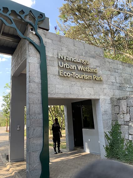
One initiative is the rehabilitation of the Nyandungu Ecological Park, called RUPDI (Rwanda Urban Development Project), 10 km from the city centre of Kigali, in an area previously known as the ‘Nyandungu Wetland.' Inaugurated on 18 July 2022, it was an area that suffered decades-long degradation from uncontrolled agricultural exploitation, commercial and industrial activity, and unplanned urban expansion (GGGI, November 2022). The Government of Rwanda and partnering stakeholders were highly committed to rehabilitate and transform this wetland into a ‘green area’ within the urban environment. Restoring it alliviated flooding, as it enhanced the wetland's 'sponge' effect to retain storm runoff from the surrounding urbanised hills, which accumulates on the valley floor.
How did the park come about?
In 2017, the Global Green Growth Institute (GGGI) signed an agreement with Italy's Ministry of Environment, Land, and Sea (IMELS) in the field of climate change vulnerability, mitigation, and adaptation in Rwanda. This was approved by Rwanda's Ministry of Environment, the Rwanda Environmental Management Authority (REMA) and the Rwanda Green Fund (FONERWA). This laid the foundation to support the government of Rwanda in implementing its Nationally Determined Contribution (NDC) to the Paris Climate Agreement. The Government of Rwanda, through REMA, developed the Nyandungu restoration project to demonstrate the potential of wetlands to abate pollution and reduce flood risk in urban areas. Restoration work started in late 2018. The opening of Nyandungu Eco-Park in Kigali represents the largest addition to public green space in the city’s history (Rwanda Development Board, 2022).
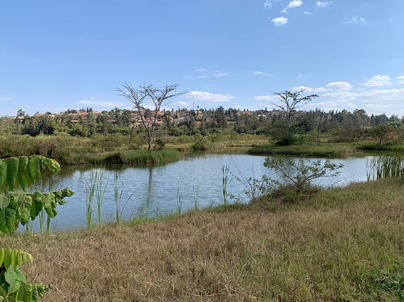
Image from WCRP. 'Ecotourist park Kigali'
The Nyandungu Eco-Park is located just next to the international airport of Kigali, with easy accessibility. The Kigali Convention Center is a 15-minute drive from the park.
Characteristics of the Park
- 121 hectares in size,
- 70 hectares of wetland
- 50 hectares of forest
- 17.000 trees
- 55 indigenous species and a medical garden with 50 species
- 100 indigenous bird species.
- 8574 m. of walkways & bicycle lanes.
- Drainage channels. Filtration plants to allow water to spread.
- Two gates with green power (solar power lighting) and sewage treatment systems will be constructed.
- Nature-viewing areas, picnic areas.
- An information center that explains the role of wetlands in conservation and ecosystem services provided
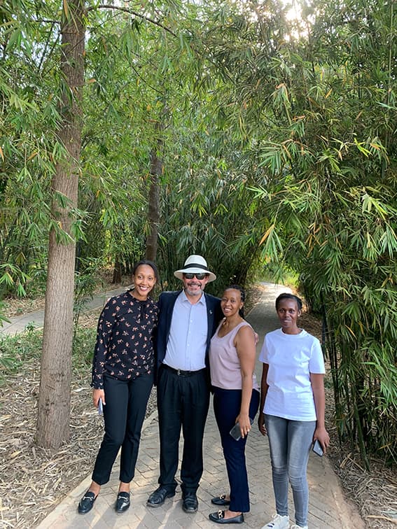
Members of the organizing committtee of the WCRP OSC 2023 in the Eco-Park
A solution to mitigate environmental disasters from flooding
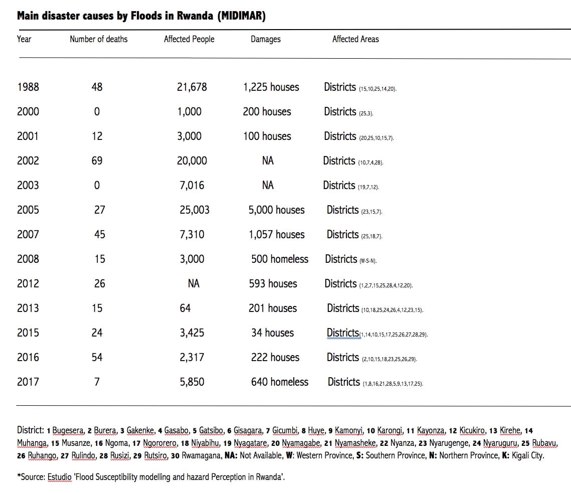
Rwanda's climatic and geographic characteristics make the country prone to flooding and landslide hazards (Mindje Mapendo,2019). According to a flood susceptibility modelling study in Rwanda, floods are the most recurrent environmental incident affecting many parts of the country. In addition, floods in urban areas, which occupy a smaller geographic area, are more intense and cause more damage than floods in rural areas (Mindje Mapendo, 2019).
Different statistical and geospatial methods were used to derive current and future trends in simulated seasonal and annual rainfall in Rwanda. Results of these studies can help in designing appropriate climate adaptation measures to achieve sustainable economic development and better livelihoods. The increased frequency and intensity of droughts and floods have threatened the livelihoods of many in Rwanda, which is why modelling for climate projections and undertaking impact studies have become effective tools. This improves understanding of both climate change impacts and future climate predictions across time scales.
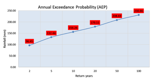
Essential metrics used in this research are the Annual Exceedance Probability (AEP) and Average Recurrence Interval (ARI). These help determine the statistical nature of storm frequency, or the percentage of a particular storm event that is exceeded in any given year compared to a baseline average. The return levels established over the historical period are then used to determine possible changes in their associated recurrence interval (Return Period in “years”) (see Climate Change Knowledge Portal).
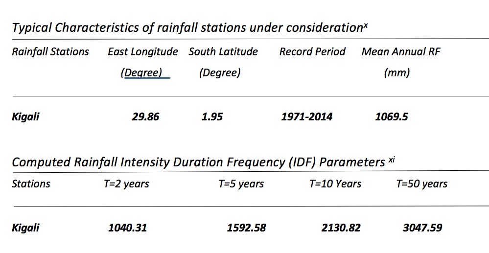
(Source: Negash Wagesho, 2016)
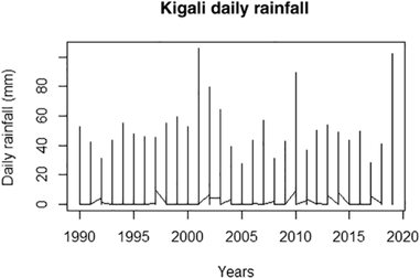
The climatology of the seasonal rainfall cycle over Rwanda shows the precipitation distribution during two rainy seasons: MAM (March, April, and May), the long rainy season, and SOND (September, October, November, and December), the short rainy season. This is combined with a short dry season (between December and February) and a long dry season (June, July, and August). Dry and wet seasons have recorded below and above-average rainfall in recent years, with increasing extreme weather events, such as droughts and floods (Joseph Sebaziga, 2020).
The MAM rainy season is controlled by mesospheric features such as topography and lakes, while SOND rainfall is controlled by large-scale phenomea like the El Niño Southern Oscillation (ENSO), Indian Ocean Dipole (IOD), and subtropical anticyclones. It should be noted that the convergence of anticyclones (i.e., the Mascarene High, which is located off the coast of Madagascar and feeds into the coast of Mozambique, and the St Helena High, which is transported from the South Atlantic Ocean to the Congo Basin and then to Lake Kivu) leads to an anomalous amount of rainfall during the MAM season. Climate studies in Rwanda predict an increase in temperatures of up to 2.5°C between 1970 and 2050 and increases in average annual precipitation of up to 20% over the same time period (Joseph Sebaziga, 2020).
Source: Priscilla Niyokwiringirwa, S2530988-Climate Impact Analysis. 2 July 2021
Source: Royal Meteorological Society (RMETS).
How do wetlands reduce flooding?
 Wetland ecosystems significantly impact soil infiltration and rainfall runoff. Vegetation slows surface water movement (e.g., from rain or runoff), allowing greater soil infiltration capacity compared to impermeable surfaces like roads, tarmac, and residential areas (Yang J-L and Zhang G-L, 2011). Vegetation-covered soil functions like a ‘sponge’ with a limit to how much water can be absorbed before becoming saturated and flooding overflow occurs.
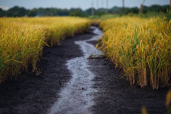
Photograph Thahn Nguyen
Second part of ‘the wetland rehabilitation project in Rwanda’
A second urban development project (RUDPII), also aimed at increasing resilience and strengthening integrated urban planning and management, has already been launched following the successfull rehabilitation of the Kigali National Eco-Park. Plans are to rehabilitate wetlands in other flood-harmed areas around Kigali, such as Kinamba, Rugunga, Rwandex-Majerwa, Mulindi, Masaka, and Gacuriro. The project will run from 2021-2025. Find out more about the Kigali Wetland Master Plan (World Bank Group, Kigali, Rwanda).
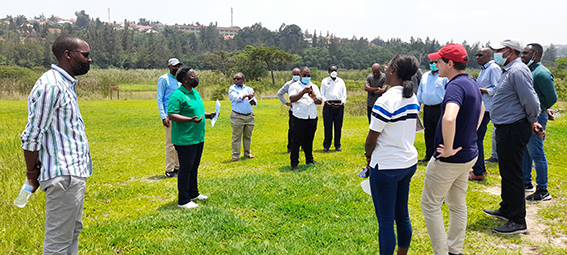
Image source: Rwanda Environmental Management Authority (REMA)